Newly completed gold mineral resource estimate (Fall 2026)
Large, open-pit constrained gold inventory with approximately 80% of contained ounces in Measured & Indicated
Significantly enhanced geological model sets stage for further resource definition and engineering work
M%I
2.0
Moz
Au
0.84
g/t
Au
Inferred
0.5
Moz
Au
0.62
g/t
Au
80%
M&I OUNCES
Resource Category
Mt
Au g/t
Moz Au
Measured
18.9
1.00
0.606
Indicated
55.5
0.79
1.403
Measured + Indicated
74.4
0.84
2.009
Inferred
24.5
0.62
0.491
Tonnes and ounces rounded; totals may not add due to rounding
Key Assumptions
US$3,000/oz Gold Price
0.20 g/t Cut-off
88.5-94.5% Recovery
Open Pit Constraint
4.2 km
STRIKE LENGTH
833
HISTORICAL HOLES
237 km
DRILLING DATABASE
6 east-plunging
INTERPRETED SHOOTS
Proposed Growth Program
20 holes
11,150 m
Open Pit Growth
Underground Potential
Supplemental Metallurgy
AZ Discovery
Tungsten Opportunity
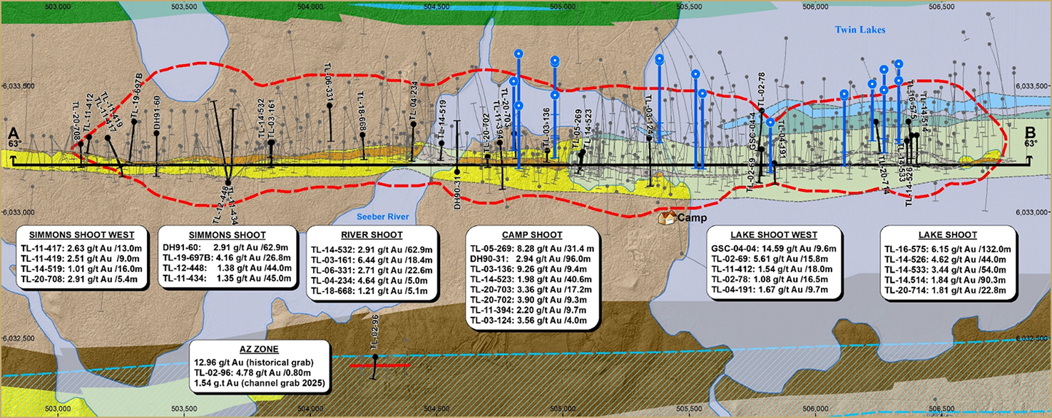
Proposed Drill Targets - Plan View
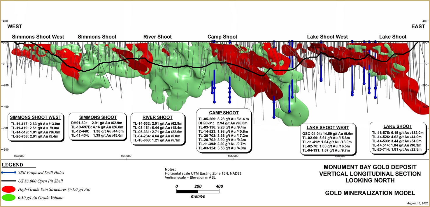
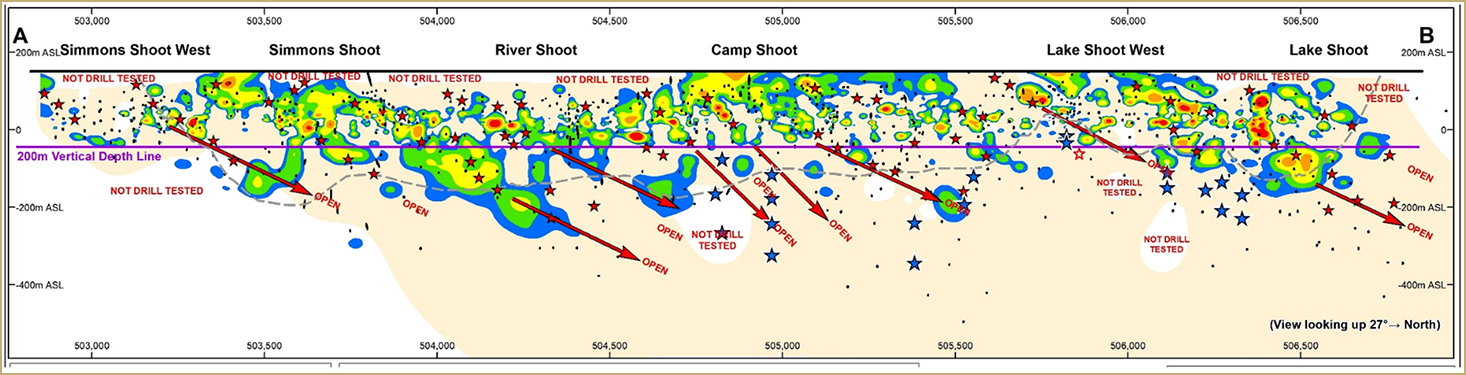
Long Section - Open / Sparsely Drilled Targets
(largely untested below ~300 m)
01
Grow the open-pit resource
Test higher-grade continuity in central and eastern shoots; target mineralization below / beyond the current shell and convert sparsely drilled areas.
02
Define underground potential
Six east-plunging shoots remain open. Lake Shoot hole TL16-575 returned 6.15 g/t Au over 132.0 m, including 163.92 g/t over 2.75 m.*
03
Test the AZ Target
Located ~800 m south of the main shear: historical grab samples up to 12.97 g/t Au, limited drilling and an apparent ~1.2 km IP trend.
04
Tungsten Opportunity
Further evaluation of tungsten distribution, geological controls and its association with higher-grade gold mineralization.
Targeting Resource Growth and New Discovery Sources on Parallel Regional Structures
District Target Inventory
31,250 ha
Property
5
Priority Areas
15
IF Potential Au Targets
8
Strong VTEM Targets
01
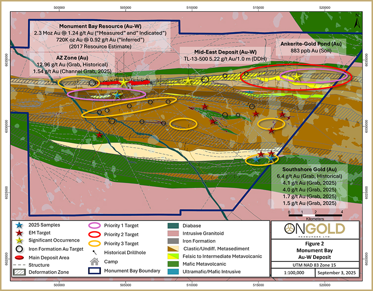
AZ Zone – South Limb Deformation Zone
Near-camp structures with historical high-grade samples, limited drilling and broad IP anomalies.
02
Monument Bay west and east extension
~2.67 km of sparsely tested TLSZ immediately west of the deposit, with limited sampling and untested IP. Sparsely drill tested to the east as well.
03
Gold Ridge
Grabs up to 6.4 g/t Au over 1.25 km strike length in the Stull-Wunnumin Deformation Zone
04
Ankerite-Gold Pond / Mid-East
5 km of undrilled TLSZ east of Mid-East; IP and soil anomalies include values up to 883 ppb Au.
05
Mid-East Zone
~ Shallow drill tested historically; investigate deeper target testing below know gold zone in search of a deeper felsic dyke source for gold mineralization.