Toronto, Ontario, March 2, 2026– ONGold Resources Ltd. (the “Company” or “ONGold”) (TSXV:ONAU) (OTCQB:ONGRF) is pleased to provide an update on the key outcomes of the Monument Bay gold and tungsten project geological and structural review undertaken as part of the historical core re‑logging and infill sampling program initiated during the summer of 2025. The field program was recently concluded, resulting in the completion of the strategic re-logging of 83 historical drill holes totaling 11,400 metres (m) of core on 19 drill sections (Figure 1). The Company also today announced that Rodney Barber, President of ONGold, will be leaving the company effective March 31, 2026. The company thanks Mr. Barber for his contributions and wishes him well in his future endeavors. Paul Dunbar, ONGold’s Vice President of Exploration, will assume remaining geological planning duties.
The Monument Bay deposit has been historically drill tested by 615 holes totaling 172,147 m over a strike length of 4.2 kilometers. Importantly, the deposit remains open at depth and is largely untested by drilling below a vertical depth of 300 meters from surface, presenting significant potential for resource expansion through deeper exploration and future drill testing. The updated geological interpretation confirms that a significant portion of the deposit’s vertical extent remains unconstrained, representing meaningful upside to the existing historical resource base. The core re-logging and infill sampling program was designed to strengthen the geological understanding of both the structural and geological controls for gold and tungsten mineralization across the entire 4.2 km strike length of the deposit thereby supporting a new mineral resource estimate to be completed by SRK Consulting (Canada) in 2026.
Highlights:
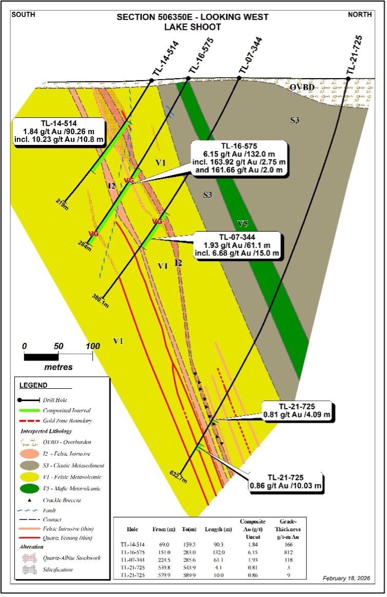
- High Grade Gold Intercepts Identified: The highest‑grade gold intercepts occur in the eastern portion of the deposit near surface, where the felsic sill thins but strong mineralization and alteration continue along the Twin Lakes Shear Zone (“TLSZ”); Drill Section 506350E, hole TL16-575 returned 6.15 g/t Au over a core length of 132m (Figure 2).
- Gold Grade Continuity Confirmed: Relogging has verified consistent gold grade continuity along the 4.2 km strike length across the deposit drill sections.
- Gold Extends to Surface and Remains Open at Depth: The program has confirmed that gold mineralization reaches surface and remains open at vertical depths exceeding 300 m from surface, and towards the east supporting the potential for resource expansion.
- Gold Structural Controls Defined: Gold mineralization is associated with felsic intrusive sills with higher‑grade zones concentrated within brecciated and stockwork vein systems.
- Improved Geological Model Established: The geological model has been streamlined to four principal units, each aligned with the structural interpretation controlling gold mineralization.
Kyle Stanfield CEO and a Director of ONGold commented: “Soon after acquiring the Monument Bay gold project from Agnico Eagle in late 2024, we set out on an ambitious program of deepening the geological understanding of the deposit which has now been successfully concluded. As a result of this extensive geological review combined with the current gold price and critical minerals environment, the Monument Bay deposit represents an entirely new opportunity as we complete a new mineral resource estimate in 2026. Infill diamond drilling of identified resources will be an important next step after the new NI 43-101 resource is published.”
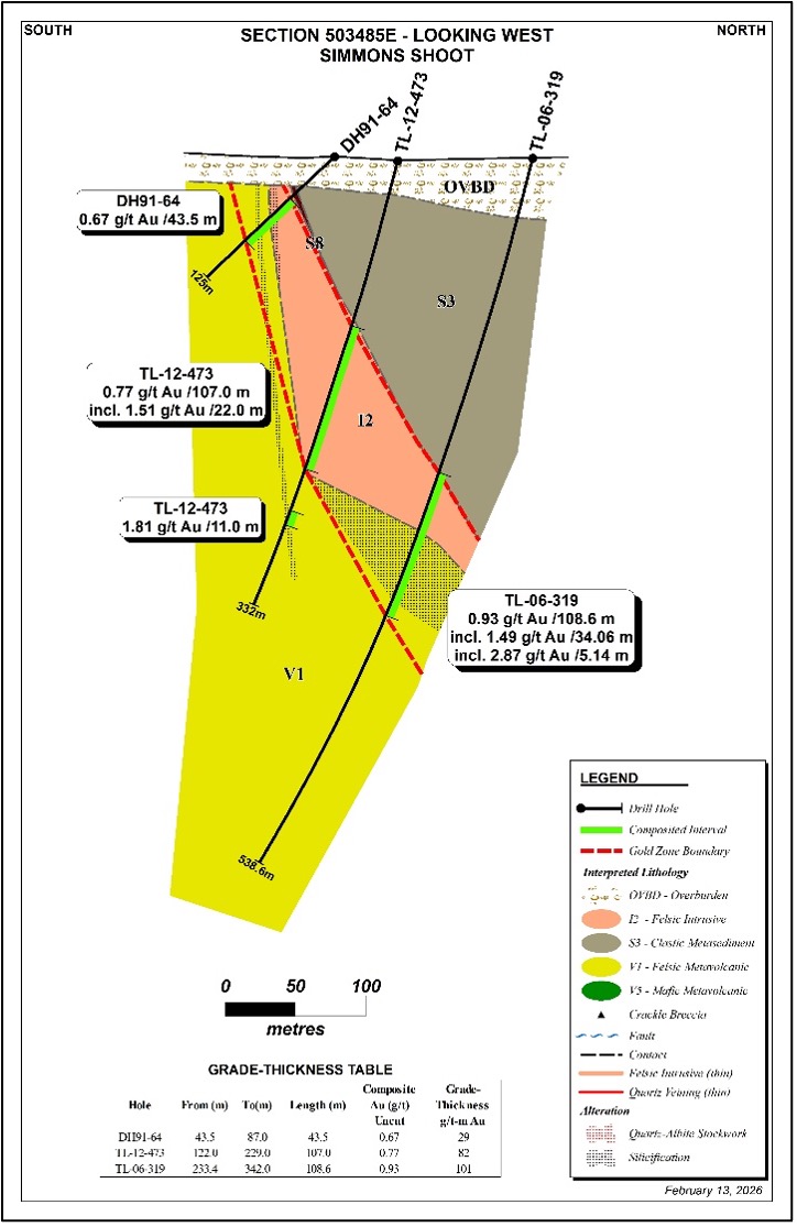
Figure 1- Plan map showing drill holes and 19 Re-logged Sections Including Drill Sections 503485E (Simmons Shoot) and 506350E (Lake Shoot Area)
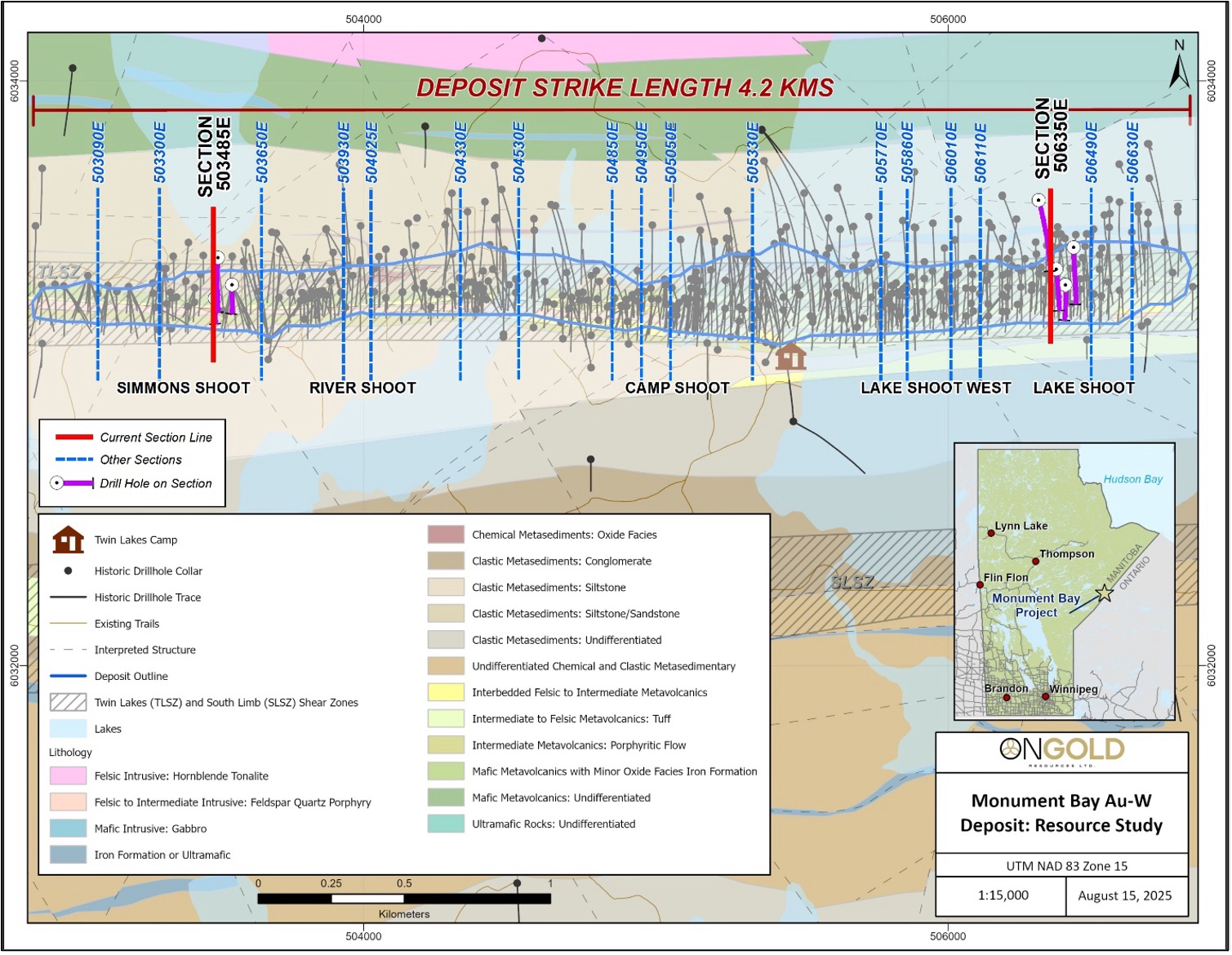
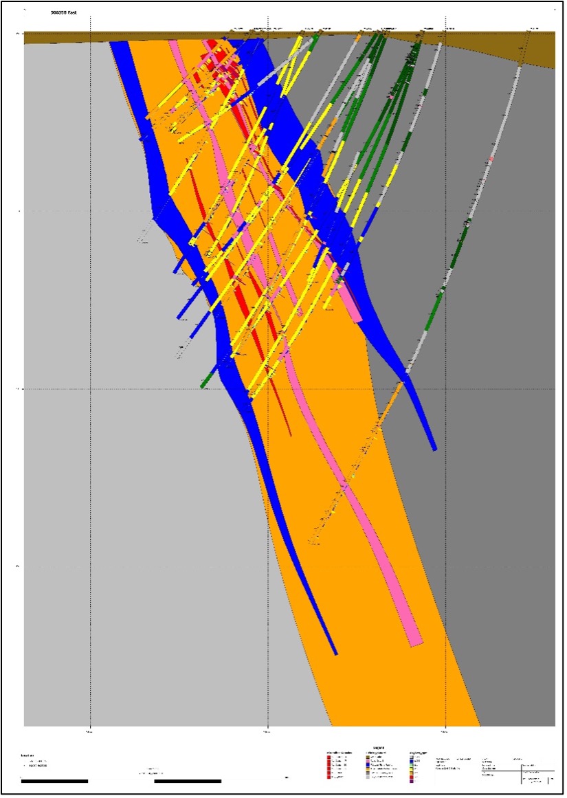
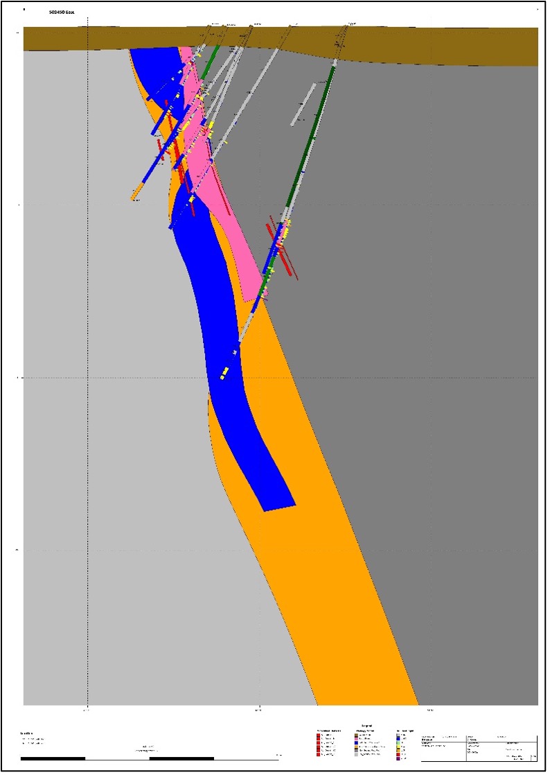
Figure 2: Drill Section 506350E: Relogging by ONGold Versus Yamana Gold
ONGold Resources Ltd. 2025 Re-logging – Detailed Geology Gold-Bearing Stockwork Veins/Shears Well Defined
2021Yamana Gold Original Drill Section: Absent of Detailed Geology and Defined Mineralization Structural Controls
Relogging of the historical drill core continued to identify sections of mineralized and unsampled felsic sill and altered sheared, veined, and mineralized core that was not previously sampled. Unsplit core has been sampled by the ONGold team for both gold and tungsten.
The highest-grade gold drill hole composites over significant core lengths have been identified to vertical depths of 200-300 m in the eastern portion of the deposit, east of the Lake Shoot on drill section 506350E, where the main felsic sill appears as narrow dykes or stringer dykes (stretched out) within the TLSZ, hosted in altered metasedimentary and volcanoclastic rocks (Figure 1 Location Map; Figure 2). Notable historical gold assay composites over specified core lengths on that section are as follows:
- TL-14-514: 1.84 g/t Au over 90.26m (69.00 to 159.26) including 10.23 g/t Au over 10.80m (73.60 to 84.40).
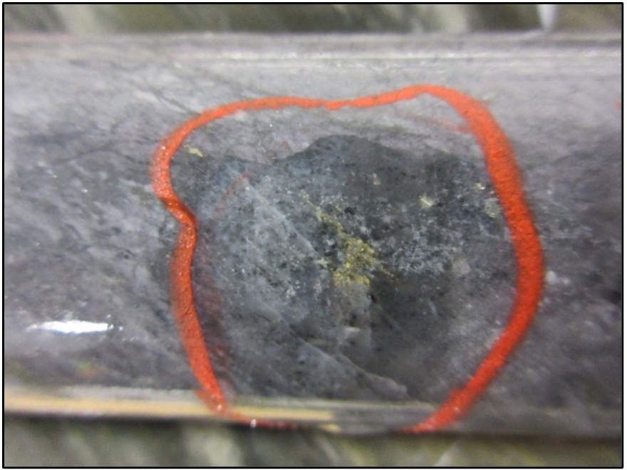
- TL-16-575: 6.15 g/t Au over 132.0 m (151.00 to 283.00) including 163.92 g/t Au over 2.75m (171.25 to 174.00), including 691.09 g/t Au over 0.65m (171.25 to 171.90m: Visible Gold Figure 3) and 161.66 g/t Au over 2.0m (260.00 to 262.00).
- TL-07-344: 1.93 g/t Au over 61.10m (224.50 to 285.60) including 6.68 g/t Au over 15.0 m (224.50 to 239.50).
The wider zone divides into two narrower zones at depth intersected by hole TL-21-725 returning 0.81 g/t Au over 4.09m (539.80 to 543.9m) and 0.86 g/t Au over 10.30m (579.90 to 589.90m).
In the Western end of the deposit, the gold-bearing felsic intrusive body of the Simmons Shoot on drill section 503485E is located at the contact between hanging wall clastic and metasediments and the footwall felsic to intermediate metavolcanics. This section contrasts with Section 506350E as here the felsic sill is thicker (Figure 1 Location Map; Figure 4, Simmons Shoot). The gold grade is consistent with the mineralized zone widening at depth (from 43.50 m near surface to 108.60 m at a depth of 300 m) and remains open at depth with increased grade-thickness. Notable historical gold assay composites over specified core lengths on that section are as follows:
- DH91-64: 0.67 g/t Au over 43.5 m (43.50 to 87.00 m).
- TL-12-473: 0.77 g/t Au over 107 m (122.00 to 229.00 m) including 1.51 g/t Au over 22.00m (170.00 to 192.00m).
- TL-06-319: 0.93 g/t Au over 108.60 m (233.4 to 342.00 m) including 1.49 g/t Au over 34.06m (238.04 to 272.10 m), 2.875 g/t Au over 5.14m (266.96 to 272.10 m).
Figure 3: TL-16-575: Visible Gold in Narrow Altered (Silica/Sericite) and Brecciated Felsic Sill; 20 flecks of Gold in Association with 3% Pyrite and 2% Scheelite; Returned 691.09 g/t Au over a core length of 0.65 m (171.25 to 171.90m)
The core re-logging program has been instrumental in providing a more consistent and improved geological interpretation of the principal mappable mineralized rock units across the deposit and defining the gold-bearing structures allowing for enhanced 3D geological modelling in support of the resource block model for the updated NI 43-101 compliant resource estimate to be prepared by SRK Consulting (Canada) Inc. This is illustrated in Figures 2 and 4 when comparing the more detailed geological interpretation with the historical sections completed by Yamana Gold.
Data Integrity and QA/QC
Assay results for tungsten have been received for over 12,000 historical pulp samples; a sampling program designed to collect missing assay data from historical holes throughout the deposit. These pulps, originally stored at the Kam River facility in Thunder Bay were dispatched to the laboratory in the late fall of 2025. The assay results are currently undergoing quality assurance validation. New gold and assay data will then be integrated into the database to be captured into the new resource update.
As part of ONGold’s internal quality assurance and quality control procedures, 1,204 historical pulps were submitted to the primary laboratory for gold validation analyses; pulps that originate back as far as the 2003 drilling program by Bema Gold Corporation. Comparative analyses of the original gold versus duplicate gold fire assaying demonstrated a very close correlation.
Figure 4: Drill Section 503485E: Relogging by ONGold Versus Yamana Gold
ONGold Resources Ltd. 2026 Re-logging – Detailed Geology Gold-Bearing Stockwork Veins/Shears Well Defined
2021Yamana Gold Original Drill Section 503450E (Closest) Detailed Geology and Defined Mineralization Structural Controls
Historical Resource Estimate of the Monument Bay Deposit
The last official gold resource estimate was completed in 2017 by Yamana Gold and did not include tungsten. ONGold’s published NI 43-101 technical report published on sedarplus.ca in 2025 discloses a historical gold mineral estimate of approximately 2.3 million gold ounces (58.0 million tonnes at an average grade of 1.24 g/t) in the “Measured” and “Indicated” Mineral Resources categories, and 720,000 gold ounces (24.4 million tonnes at an average grade of 0.92 g/t) in the “Inferred” Mineral Resources category (see Press Release Dated June 13, 2025). This consists of in-pit resources above a cut off grade of 0.30 g/t gold.
These historical mineral estimates, although compliant with NI 43-101 guidelines at the time they were prepared, are historical and should not be considered current. A qualified person has not completed sufficient work to classify this historical estimate as current mineral resources or mineral reserves and accordingly it should not be relied upon. The author and the Company are not treating the historical estimate as current mineral resources or mineral reserves. To verify the historical estimate, a qualified person needs to review the historical data, review any work completed at Monument Bay since the date of the historical estimate and complete a new mineral resource estimate. The author of the Technical Report and the Company view this historical estimate as a conceptual indication of the potential size and grade of the gold-tungsten deposit in the area, and this information is relevant to ongoing exploration efforts.
No mineral reserves have been defined at Monument Bay.
Sampling, QA/QC and Analytical Methods
Quality Assurance/ Quality Control (“QA/QC”) procedures were executed to ensure all work is conducted in accordance with best practices. Drill core of various sizes was logged and sampled by Company personnel.
Sample sizes respect both geological and mineralized contacts and generally range from 0.3m to a maximum length of 1.0 m. Drill is cut in half, or quartered (historical core), with the other half retained for future verification. The other half of the core is placed in strong plastic sample bags, a sample tag placed in the bag and the bag numbered, with a permanent magic marker with the sample number. Coarse blanks and certified reference standards (Oreas) as inserted by the geologist into the sample stream every 10th sample. Each bag is then individually sealed using strong zip ties. Sample batches of ten (10) are placed in security tag-sealed rice bags for shipment to the laboratory. Sample submission forms are completed as a part of the chain-of-custody tracking process with sample dispatched to the laboratory with ONGold personnel or contracted courier services.
Samples are then analyzed at Actlabs in Thunder Bay, Ontario, the company’s primary analytical laboratory. ONGold always uses labs that are both ISO 17025 and ISO 9001 certified. Upon receiving the samples, the laboratory sends ONGold a sample submission confirmation email verifying that the samples have been received and will advise if any security tracking tags have been tampered with or lost in the process.
At the lab, samples are organized for internal tracking, dried and prepared using RX1 sample preparation handling. The entire sample is crushed to a nominal -2 mm, mechanically split to obtain a representative sub-sample and then pulverized to at least 95% -105 microns (μm). All steel mills are mild steel and do not introduce Cr or Ni contamination. Samples are initially analyzed by 50-gram fire assay with atomic absorption finish (1A2-50). Any sample assaying greater than 5.0 g/t Au is re-assayed by fire assay gravimetric analyses (1A3-50) which has an upper detection limit of 10.0 g/t Au. Samples exceeding 10.0 g/t Au or those samples identified as containing visible gold are analyzed by 1,000-gram gold-fire assay metallic screen analysis (1A4-1000).
Geochemical analyses consist of near total digestion analyses for 35 elements, including tungsten, by ICP which has a maximum detection limit for tungsten (W) of 10,000 ppm. Overlimit samples for tungsten are analyzed using XRF (Code 8-XRF W). If a coarse blank or certified reference standard fails, then five (5) samples on either side of the failed samples are re-assayed by the lab, including the standard, and if the issue has been resolved, the new assays are entered as finals in the database.
Once all the final assay reports are received, 10% of the pulps are dispatch from Actlabs directly to a secondary laboratory for assay verification as part of the QA/QC procedures; in this case AGAT Laboratories in Thunder Bay. For field samples, 5% of the samples are dispatched for verification.
Qualified Person
The scientific and technical information in this news release has been reviewed and approved by Paul Dunbar, P.Geo., Vice President Exploration of ONGold, a ‘Qualified Person’ under NI 43‑101 (not independent). Data verification included (i) review of historical drilling and assay database records for the drill holes referenced herein, (ii) review of core logging and sampling records from the 2025 re‑logging program, and (iii) check assays on a subset of historical pulps (including the 1,204 pulps described in this news release) to compare original and duplicate gold results. Limitations: the QP has not verified all underlying historical data for the entire 615‑hole dataset and verification is limited to the referenced holes and the described check‑assay program. Ongoing verification of scientific and technical information is achieved by direct involvement in the exploration work.
About ONGold Resources Ltd.
ONGold Resources Ltd. owns significant exploration assets in Northern Ontario and Northern Manitoba, including the district-scale Monument Bay Gold-Tungsten Project, TPK Gold Project, Domain Gold Project and October Gold Project. These projects represent a strategic footprint in one of Canada’s most prolific gold-producing regions.
ONGold Resources Ltd. on behalf of the Board of Directors
Kyle Stanfield, Chief Executive Officer & Director
Contact Information
Kyle Stanfield
Chief Executive Officer
Telephone: 1 (647) 749 5836
Email: info@ongoldresources.com
Neither the TSX Venture Exchange nor its Regulation Services Provider (as that term is defined in the policies of the TSX Venture Exchange) accepts responsibility for the adequacy or accuracy of this release.
Forward-Looking Information
This news release contains ‘forward-looking information’ and ‘forward-looking statements’ within the meaning of applicable Canadian securities laws (together, ‘forward-looking information’). Forward-looking information herein includes, but is not limited to, statements regarding the timing, scope and results of the updated mineral resource estimate, the interpretation of geological information, the potential for resource expansion and conversion, planned sampling, surveys and drilling, and the timing of future work programs. Readers are cautioned that the historical mineral resource estimate disclosed in this news release is not current and may differ materially from any future mineral resource estimate. Forward-looking information is based on reasonable assumptions made by management at the date hereof, including assumptions regarding current and planned exploration activities, availability of financing, commodity prices, permits, laboratory turn-around times, and general business and economic conditions. Forward-looking information is inherently subject to known and unknown risks and uncertainties that may cause actual results to differ materially, including risks related to exploration, sampling and assay results, geological interpretation and model risk, commodity price volatility, access, permitting and environmental matters, financing, contractor and equipment availability, and regulatory approvals. Readers are cautioned not to place undue reliance on forward-looking information. The Company does not undertake to update any forward-looking information except in accordance with applicable securities laws.